NEW Student Services Building Project
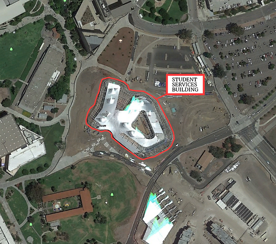
PROJECT LOCATION
SERVICES
GPS Control network (Trimble Business Center (TBC))
A GPS Control Network will be created around the new Cal Poly Pomona Student Building utilizing Fast Static PPK with three bases and multiple rovers. The three bases will be placed on the outer perimeters to bound the project site and the rovers will have an occupation time of approximately 20 minutes for each control point. In addition, CORS will be used in the adjustment of the network. Geo-referencing of both the Terrestrial Scan and UAV Photogrammetry (aerial targets) will be based off the control points that have been adjusted.
Terrestrial scanning (Trimble TX8, Trimble Realworks )
Scan stations will be positioned either on a known control point or inter-visible to prior and succeeding scans. Registration spheres will be placed on control points that can be seen within multiple scans, this will help accurately register each scan as well as geo-reference the completed registered scan. Identifiable congruent features in two scans can also be used to help with the registration. Once registration and geo-referencing is complete, modeling the student building utilizing Realworks' and/or Revit's modeling tools will allow for the process known as Building Information Modeling (BIM): analyzing the scan model against the design model.
Mobile Laser scanning (LiBackpack C50, LiDAR360 )
The LiBackpack C50 will be used for mobile laser scanning. The LiBackPack is an advanced SLAM-based 3D mapping system that integrates LIDAR that provides an accuracy of +/- 3cm with a scan range of 100 meters. It allows users to visualize data in real-time with a wired or wireless device that provides a user interface that displays data information. Before Data is gather in the field, a travel path is planned on how data will be gathered. A closed loop route was planned beginning on the east side of the new building and around the building parameter. The Libackpack C50 optimizes a SLAM algorithm to generate an indoor map. SLAM technology can create maps of space and determine the location of a device within that space using LIDAR to tactical sensors. LiDAR360 was used to manually register the point cloud data sets that was gather in the field.
UAV Photogrammetry (Inspire 2 w/ Zenmuse X4S, DroneDeploy, Bentley Context Capture)
A Flight Plan is created using DroneDeploy software to obtain a 70% side overlap, 70% forward overlap in the site photos. The Bentley Product "Context Capture" will then stitch the photos together and geo-reference the site location using aerial targets as Ground Control Points (GCPs). Not all targets will be used as control, some will be used for check points to calculate accuracy of the 3D model (point cloud). The deliverables that context capture will provide are an Orthographic photo, a Digital Elevation Model, and point cloud. A report will be created on the accuracy of our photogrammetric 3D model compared to that of a terrestrial scan. Based on previous experience and research, we predict that the UAV created model will result in an error between 0.05 ft to about 0.10 ft compared to that of the registered scan.